Earth science Satellite change detection
The changing Aral Sea
The Aral Sea once received the flow of two great Central Asian river systems. Large irrigation diversions, developed especially during the Soviet period, greatly reduced the water reaching it. As the sea shrank, fishing communities lost access to water and exposed sediments became a source of dust and salt. These satellite views show the southern sea in 2000 and 2014, when its eastern basin had largely dried. The northern and western waters have different histories. Comparing the images begins a story about rivers, agriculture and political decisions extending far beyond the shoreline.
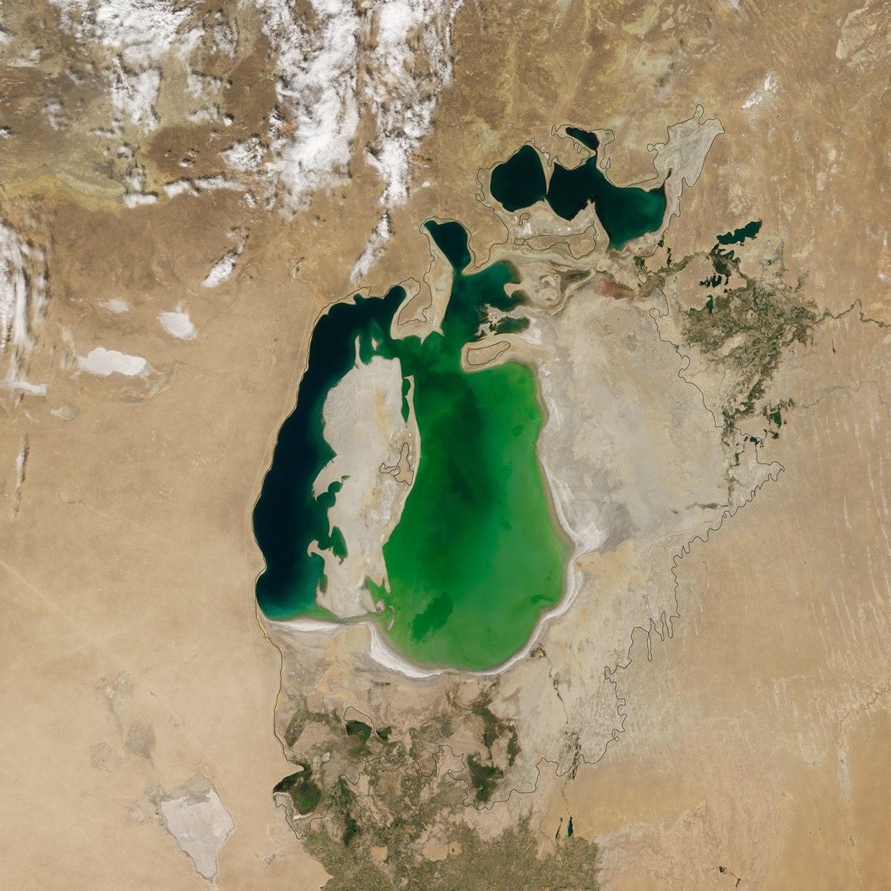
A closer look: Survey 2000
The 2000 view already shows a sea divided by years of retreat. The pale outline supplies an approximate earlier shoreline for comparison, so the image contains two kinds of information: a satellite observation and a historical reference. The missing water is the downstream result of changes throughout the river basin.
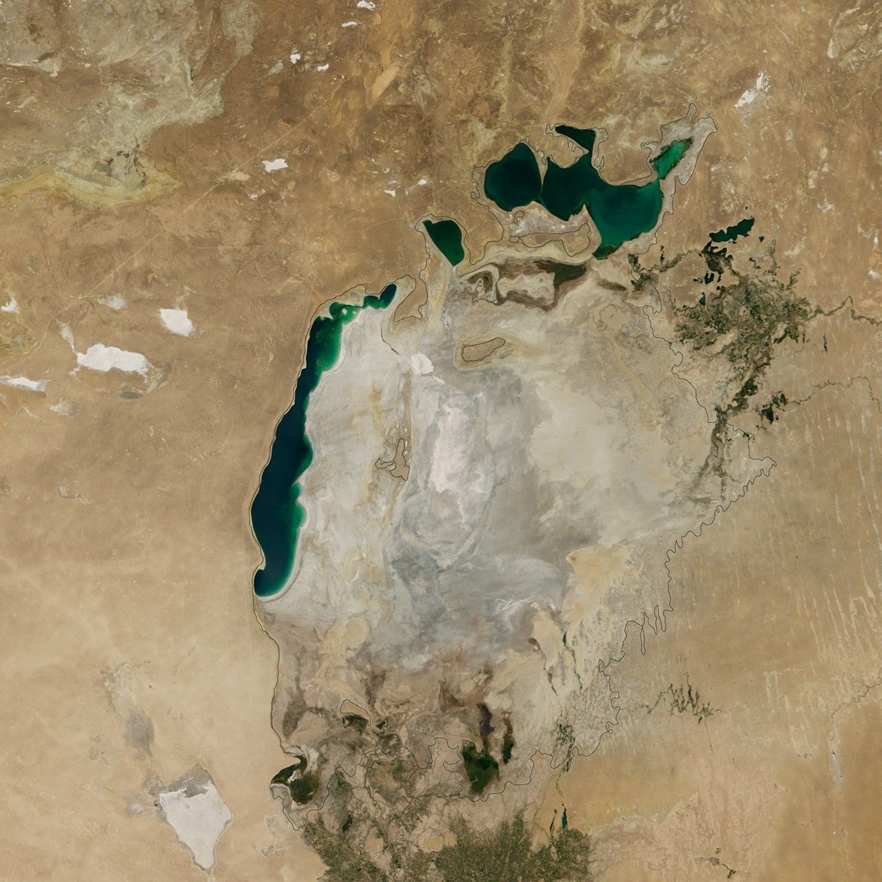
A closer look: Survey 2014
By August 2014, the eastern part of the southern sea appears largely dry in this view. Remaining water elsewhere matters: the Aral Sea did not change as one uniform basin. Rainfall, river flow, diversions and restoration efforts can affect different parts of the former sea in different ways.
The history behind it
What changed between the observations
NASA’s genuine Terra/MODIS images compare 25 August 2000 with 19 August 2014. The broad eastern lobe of the southern Aral contains conspicuous water in the first observation and exposed lakebed in the second. A long western remnant and northern waters remain. The defensible account is therefore a major change in one part of a fragmented lake system, rather than the disappearance of every visible body of water.
A reference line is not another exposure
The black outline belongs to an approximate 1960 shoreline added by the source. Its stability does not mean the water was stable, and its presence does not turn either image into a 1960 acquisition. The register is essential: it separates the two observation dates from the historical comparison boundary. Tracing the reference line as the current shoreline would replace an observed feature with an annotation.
From visible extent to a causal account
NASA’s account supplies irrigation diversion and changing river inflow as context; USGS also documents the southern basin’s retreat and later variability. Those records support investigating causes without assigning an invented exact percentage. The images here do not provide lake depths or a complete water-volume budget. A claim that irrigation caused precisely 60% of the volume loss remains undecided, not automatically false. A stronger causal estimate would require measurements matched to the interval and a method that distinguishes the contributions of competing processes.
A few things to read next
Books for a longer visit, and a few good places to start online. These are ordinary links, with no affiliate commission.
On the bookshelf
The Aral Sea: The Devastation and Partial Rehabilitation of a Great Lake
A scientific collection on the sea’s decline and the differing prospects of its basins.
Disaster by Design: The Aral Sea and Its Lessons for Sustainability
Examines the social, political and environmental consequences around the sea.
Creeping Environmental Problems and Sustainable Development in the Aral Sea Basin
A multidisciplinary study of the incremental changes that accumulated into the Aral Sea crisis.
Read online
Aral Sea
A starting point for names, dates and related subjects. Follow its references when you want to go further.
The Aral Sea Loses Its Eastern Lobe
The two MODIS observations and an explanation of the 2014 change.
World of Change: Aral Sea
A longer image sequence connects the shrinking water with river diversions.
South Aral Sea
A second satellite history from the Landsat archive.
Where the pictures come from
The original records and their individual rights statements are below. The pictures have not been generated or altered for the game.
NASA Terra/MODIS observation, 2000-08-25. Black line is the source image’s approximate 1960 shoreline, not a present water boundary.
NASA Earth Observatory, Jesse Allen / LAADS · 2000-08-25
U.S. government NASA imagery, generally not subject to U.S. copyright; editorial educational reuse with credit under NASA media guidelines. No endorsement implied.
NASA Terra/MODIS observation, 2014-08-19. Black line is the source image’s approximate 1960 shoreline, not a present water boundary.
NASA Earth Observatory, Jesse Allen / LAADS · 2014-08-19
U.S. government NASA imagery, generally not subject to U.S. copyright; editorial educational reuse with credit under NASA media guidelines. No endorsement implied.
Editorial source notes, paraphrased from NASA; these are context, not a third satellite exposure.
NASA Earth Observatory / Data Barnacle source notes · 2026-11-01
Original editorial paraphrase of federal scientific records; underlying NASA imagery is credited separately.
History notes and reading lists prepared for Data Barnacle with AI assistance. The source institutions and authors are not sponsors or endorsers. Suggest a correction or another source