Communications 1850s
The first Atlantic telegraph cable
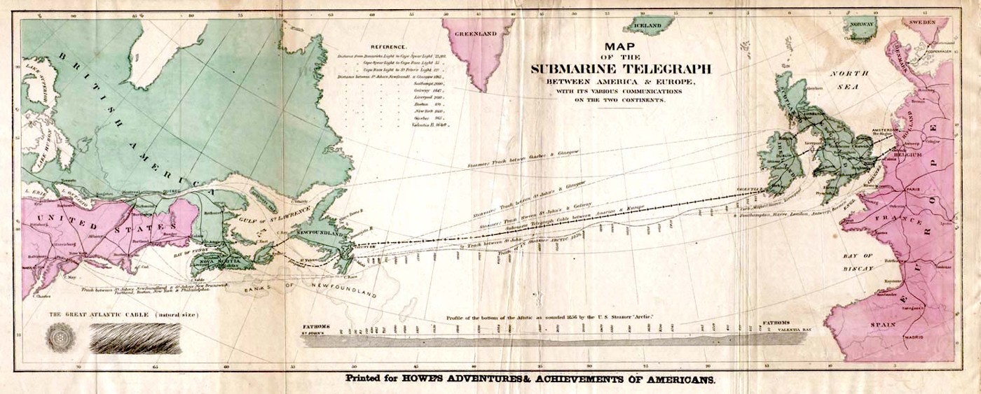
Before a transatlantic cable, a message between Europe and North America generally travelled as fast as a ship. The cable project promised to shrink that delay dramatically, but demanded difficult work at sea and reliable insulation over a vast distance. In 1858 a cable finally connected Newfoundland and Ireland. Celebrations ran ahead of its durability: that connection soon failed, and dependable service followed later. This map presents the crossing as a system, linking shore stations, steamship routes and land communications while also showing the seabed the cable had to cross.
About the picture
The lower profile turns an ocean crossing into an engineering problem: the cable must reach the bottom and survive there. The small construction detail makes its layered protection visible. Around the main crossing, steamship tracks and land links show the older and newer communications systems sharing the same Atlantic world.
The history behind it
What the source establishes
This is a map of a communications system, not just a line between two famous capitals. Newfoundland and Ireland mark the submarine crossing, while onward networks carry messages toward other cities. Steamship routes appear on the same chart and must be distinguished through their labels. The cable inset and seabed section concern the construction and placement of a physical conductor. The packet associates the project with the 1858 attempt, but a celebratory or explanatory route map cannot establish decades of successful service. That requires operational records beyond the map.
Dates, places and close alternatives
The supplied archival context associates this route with 1858; it does not date an unbroken service period. Newfoundland and Ireland are the submarine endpoints, whereas New York and London are farther along the communications system. The physical cable and bottom profile explain the infrastructure challenge; the steamship tracks provide comparison.
A network has different kinds of segments
Large destination cities, physical landing points and surface shipping routes have different roles. Report the route in segments so those distinctions remain visible. Then ask a second question: does the source establish where a link was meant to run, or how well and how long it operated? Construction context and an engineering profile can illuminate the first question without providing a complete answer to the second.
A few things to read next
Books for a longer visit, and a few good places to start online. These are ordinary links, with no affiliate commission.
On the bookshelf
A Thread Across the Ocean
Follows the people, finance and engineering behind the Atlantic connection.
The Victorian Internet
Places submarine cables within the larger nineteenth-century telegraph network.
Read online
Transatlantic telegraph cable
A starting point for names, dates and related subjects. Follow its references when you want to go further.
The Underwater Web: Atlantic Adventure
A museum account of the failed attempts, brief 1858 connection and lasting 1866 cable.
Map of the Submarine Telegraph between America & Europe
Inspect the route map, cable section and seabed profile together.
Where the pictures come from
The original records and their individual rights statements are below. The pictures have not been generated or altered for the game.
Map of the Submarine Telegraph between America & Europe, associated with the 1858 cable route.
Historical map reproduced via Wikimedia Commons; source credited to Howe’s Adventures & Achievements of Americans · Route associated with the 1858 Atlantic cable; printing date not established here
Public domain historical map; item-level source record marks the image public domain.
History notes and reading lists prepared for Data Barnacle with AI assistance. The source institutions and authors are not sponsors or endorsers. Suggest a correction or another source